About this project:
Recently, ECU archaeologists Jennifer McKinnon and Madeline Roth have been conducting research on World War II battlefield sites in Saipan and Palau. Part of their research on WWII sites includes using the KOCOA military terrain analysis (Roth 2018). KOCOA stands for analyzing Key terrain, Observation and fields of fire, Cover and concealment, Obstacles, and Avenues of approach and retreat (Roth 2018; NPS 2016:2). Conducting KOCOA analysis helps archaeologists understand the significance of landscapes in WWII battlefields in order to preserve and protect them as archaeological resources (Roth 2018; Maio et al. 2013).
The goal of this Fields of Fire model is help archaeologists like McKinnon and Roth to identify fields of fire as part of the KOCOA military terrain analysis. This model uses characteristics specific to the artillery pieces that were in these locations in conjunction with the terrain in order to determine accurate fields of fire for each gun emplacement. Examining terrain features like fields of fire will enable researchers to understand gun emplacements’ vantage points and access to enemies during battles. On a battlefield, an advantageous gun position will likely award its operators a high level of concealment and protection, which will allow a higher likelihood of remaining undetected while also being able to deal a great amount of damage upon enemies (NPS 2016:2).
Methodology:
To run the model, an elevation raster dataset is required to calculate the observer points analysis. Information on gun emplacements such as coordinates, type of gun, gun range, and fields of view is also necessary. Gun emplacement information needs to be in a shapefile format to input into the model. The gun’s field of view needs to be portrayed in two azimuth bearings, and a distance. The first azimuth bearing (Azimuth1) represents the beginning point of the field of view while the second azimuth bearing (Azimuth2) represents the ending point of the field of view. The distance is the same as the gun range but needs to be denoted in a separate column for the model (Distance column).
The parameters include the elevation (DEM) raster dataset and the gun emplacements data. The gun range data is also a parameter. Researchers can use the gun ranges from their shapefile but are also able to input another gun range to apply to all gun emplacements to create different fields of fire for a hypothetical gun range. The workspace is also parameter which will allow researchers to deposit output datasets into one designated geodatabase. These parameters will allow researchers to input their own datasets to determine fields of fire for any battlefield.
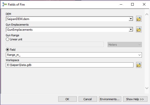
Figure 1. Parameters in Fields of Fire model (Aleck Tan 2019).
The tools needed to complete this project are observer points, reclassify, buffer, dissolve, and clip. Observer Points analysis will be conducted using the elevation (DEM) data and gun emplacements shapefile to determine visibility of gun emplacements. The tool will factor in fields of view from the shapefile. The output, Gun Observation, may result in a range of values that will be reclassified into 0 as no view from gun emplacement and 1 as available view from gun emplacement. The resulting output from this process is the Gun Observation Reclassify.
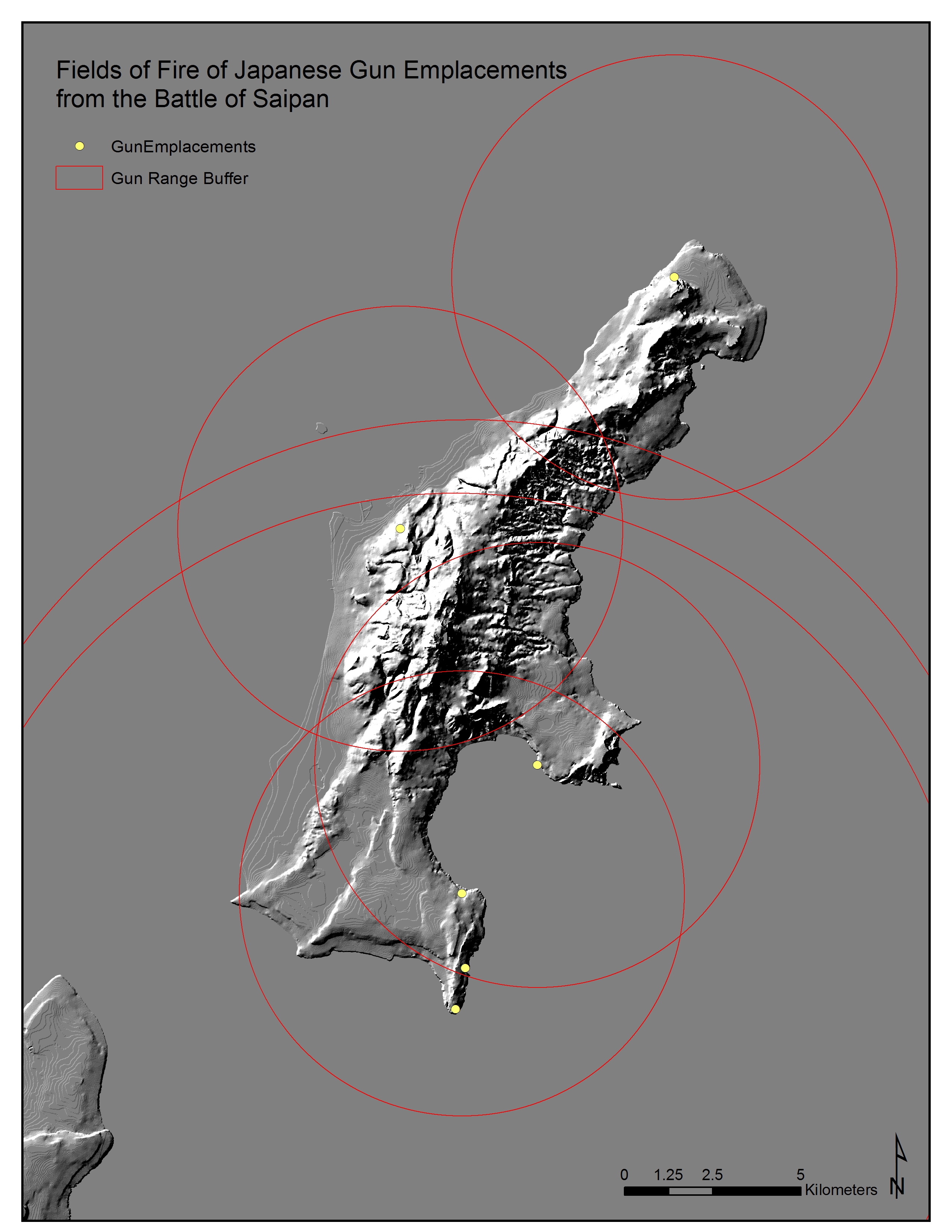
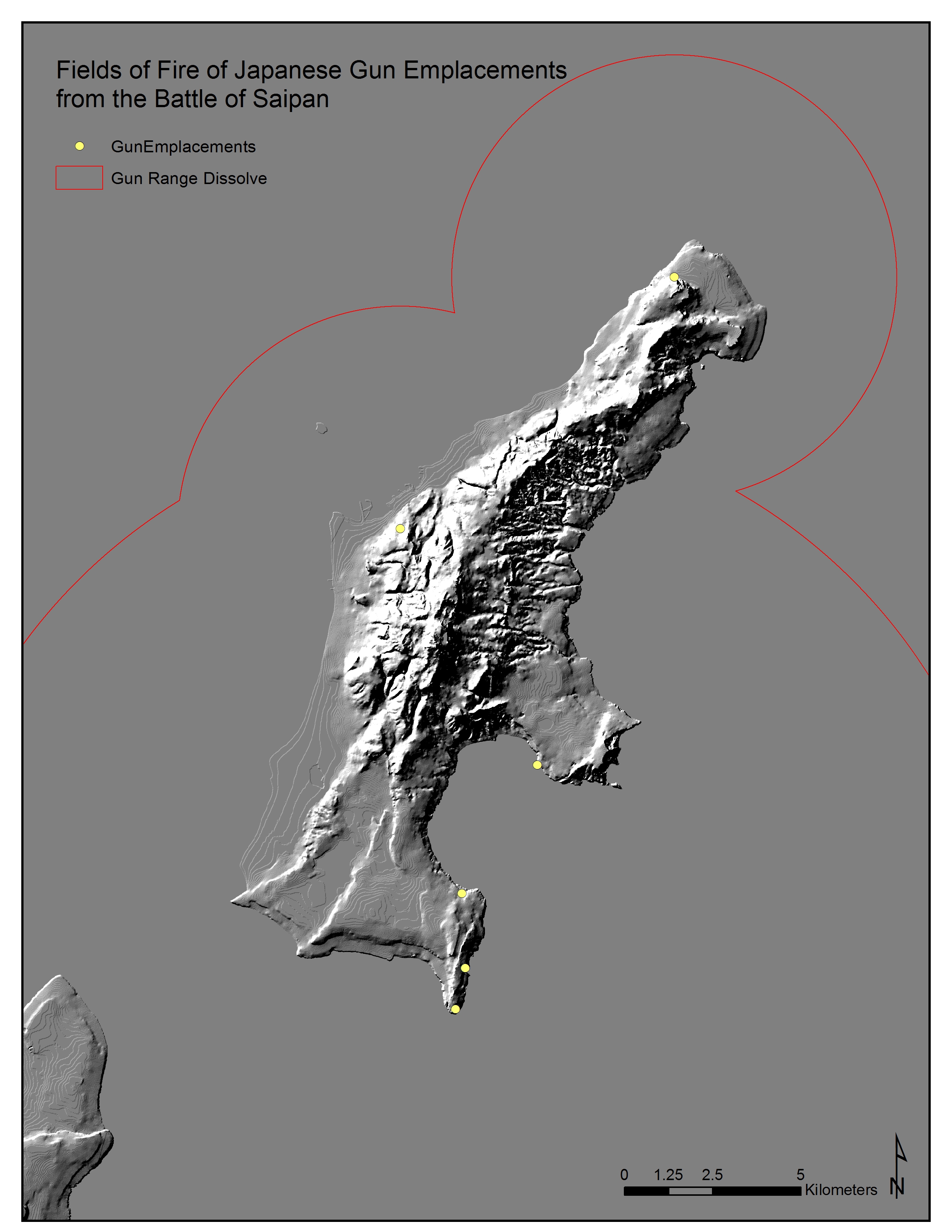
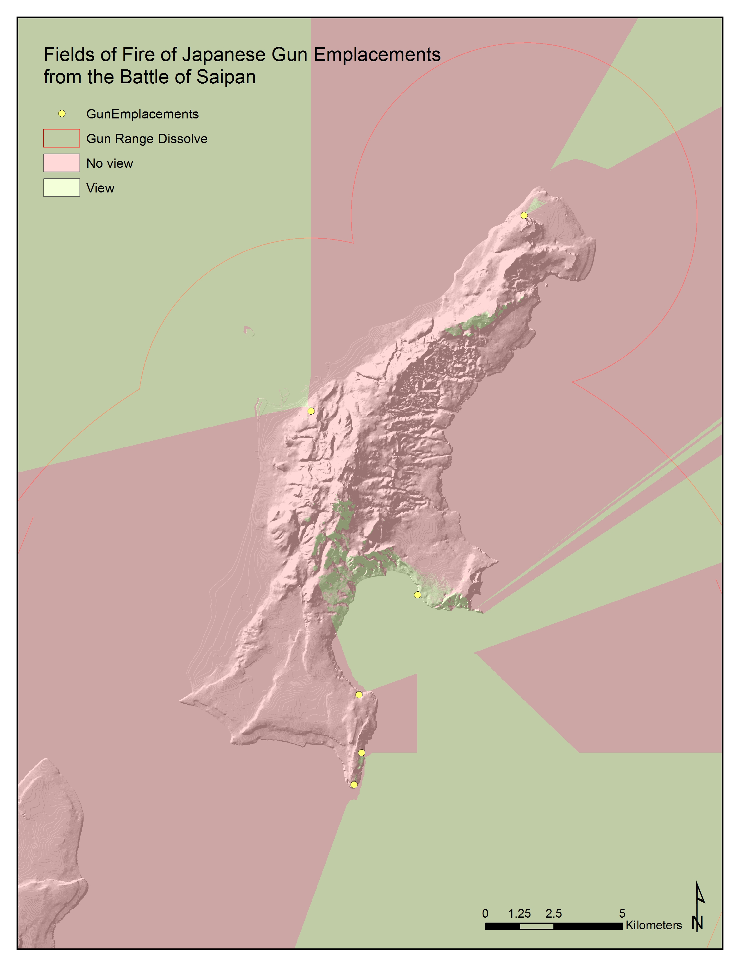
To determine gun range, buffer analysis will be conducted on gun emplacements. Buffer distances will be based on the unique gun range as provided in the gun emplacements shapefile or a designated gun range for all gun emplacements may be used. The output, Gun Range Buffer, will be dissolved to combine fields of fire of gun emplacements. The dissolved polygon output, Gun Range Dissolve, will signify fields of fire of the gun emplacements in the area. To determine what can be viewed within the gun range, the clip analysis will be conducted using the Gun Range Dissolve and the Gun Observation Reclassify. The resulting output for the model is the Observation by Range, which shows observation views within ranges of gun emplacements.
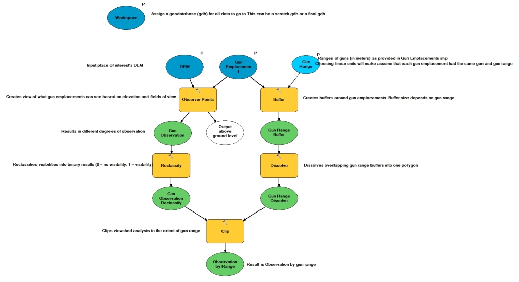
Figure 2. Fields of Fire model, a step-by-step process (Aleck Tan 2019).
Scenario Demonstration
During World War II, the Battle of Saipan took place from June 15th to July 9th, 1944 between United States forces and those of Imperial Japan. The Japanese defending the island built numerous, strategically positioned gun emplacements throughout the island with various calibres of artillery pieces. The model will use verified Japanese gun emplacements’ information and Saipan elevation (DEM) data as input datasets to visualize guns’ fields of fire during the Battle of Saipan. The model takes into account fields of view as restricted by guns’ traverse, or swivel, or by physical structures such as windows. The Fields of Fire model will create output datasets that display visibility of gun emplacements, which are limited by the gun’s range and fields of view.
Data on Saipan elevation and gun emplacements was collected for input datasets. Gun emplacement information is based on limited information online provided by Dirk Spennemann and US Army Signal Corps photographs from 1944 (Spennemann 2017; US Army Signal Corps 1944). Due to limited information on the fields of view of the selected gun emplacements, hypothetical azimuth bearings were used for the input data. There are pre-invasion maps created by US forces that display possible Japanese gun emplacements, but it was not a guarantee that the Japanese installed the guns since they were not fully prepared for US invasion forces. Ground-truthing is necessary to provide more information about gun emplacements.
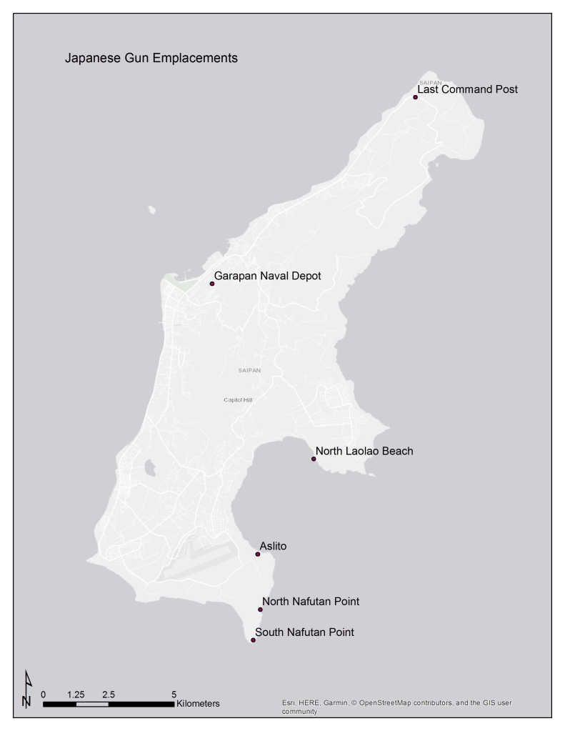
Figure 4. Approximate locations of selected Japanese gun emplacements (Aleck Tan 2019).
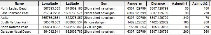
Figure 5. Gun emplacement data (US Army Signal Corps 1944; Spennemann 2017).
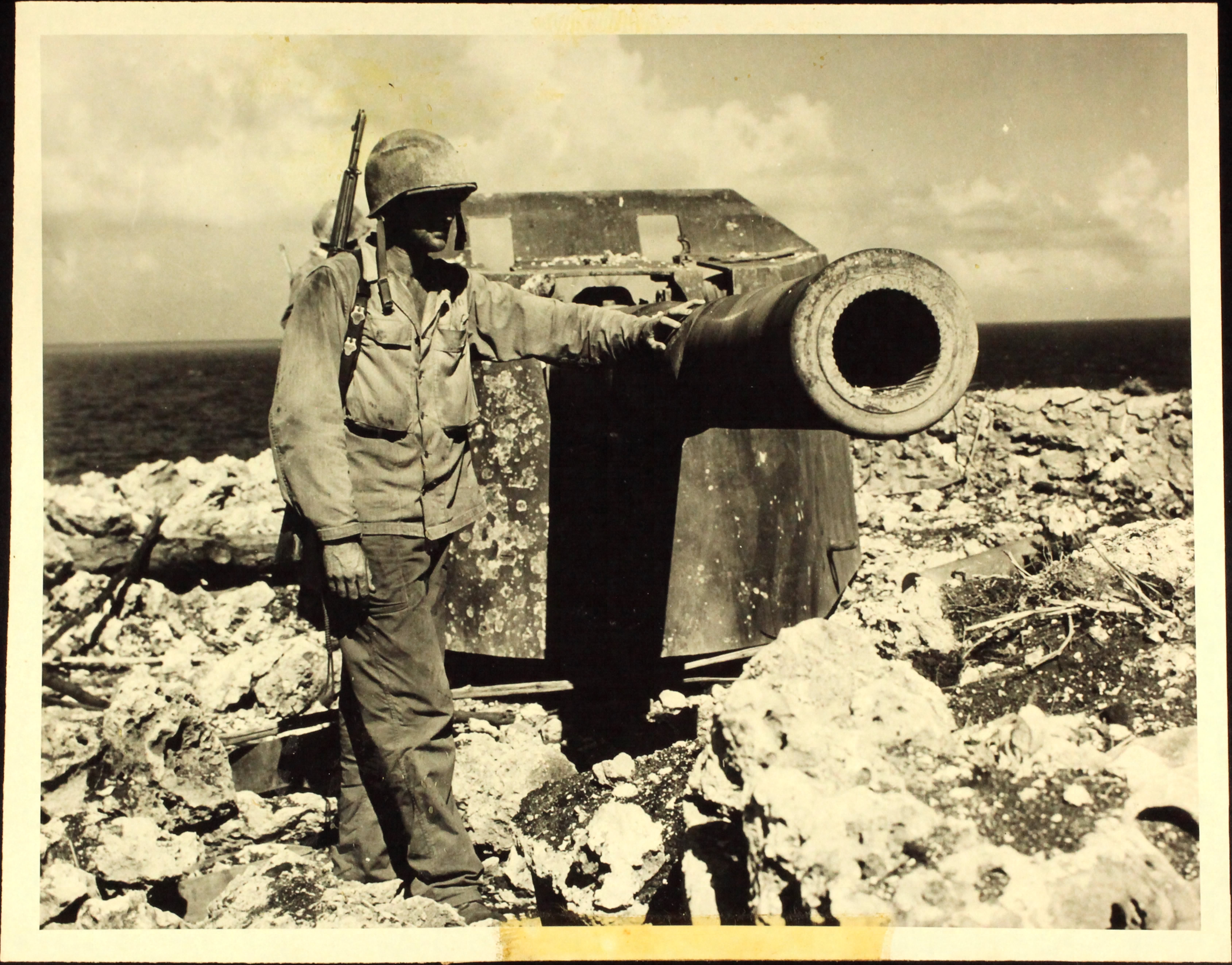
Figure 6. Japanese 6″ coastal gun at South Nafutan Point. Maximum range is approximately 14,6254 meters (U.S. Army Signal Corps 1944). 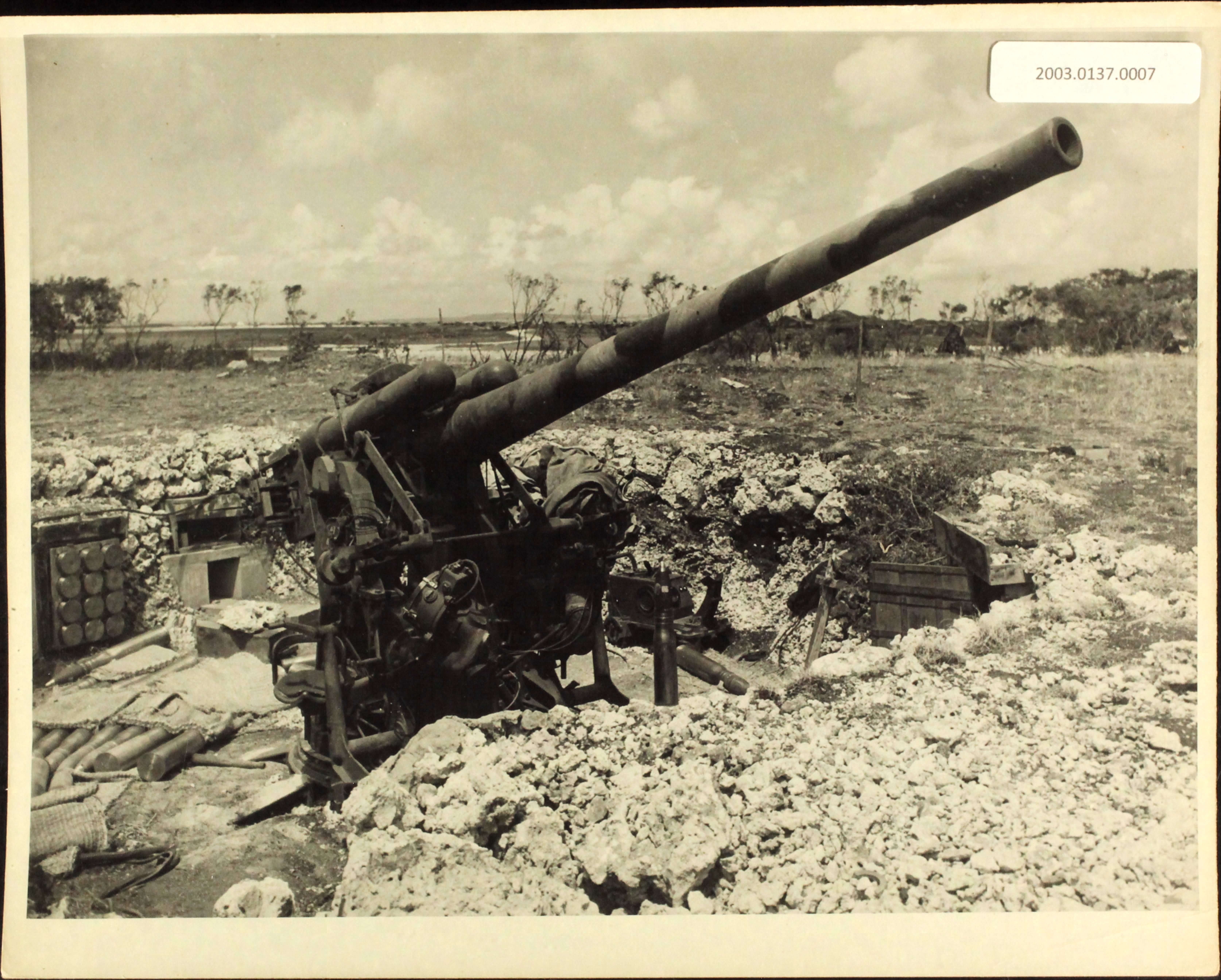
Figure 7. Example of Japanese dual-purpose 4.7” gun that may have been located in North Nafutan Point. Maximum range is approximately 15,539 meters (US Army Signal Corps 1944). 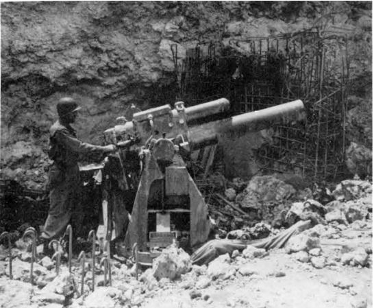
Figure 8. Unfinished concrete emplacement of a Japanese 20cm short naval gun at north Laolao Beach. Other 20cm guns were found at Garapan Naval Depot, Last Command Post, North Laolao Beach and Aslito. Maximum range is approximately 6307 meters (Vincent A. Wilson 1994).
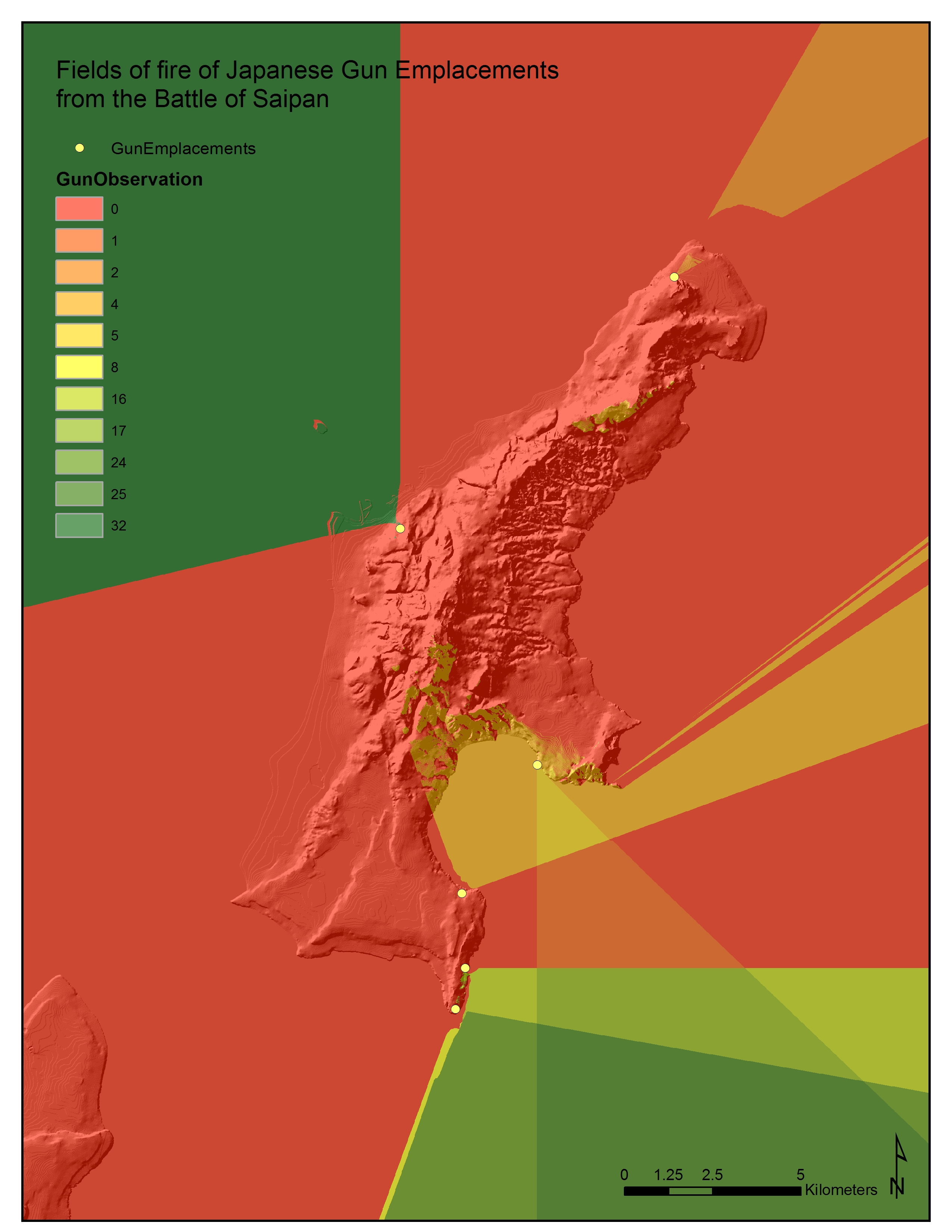
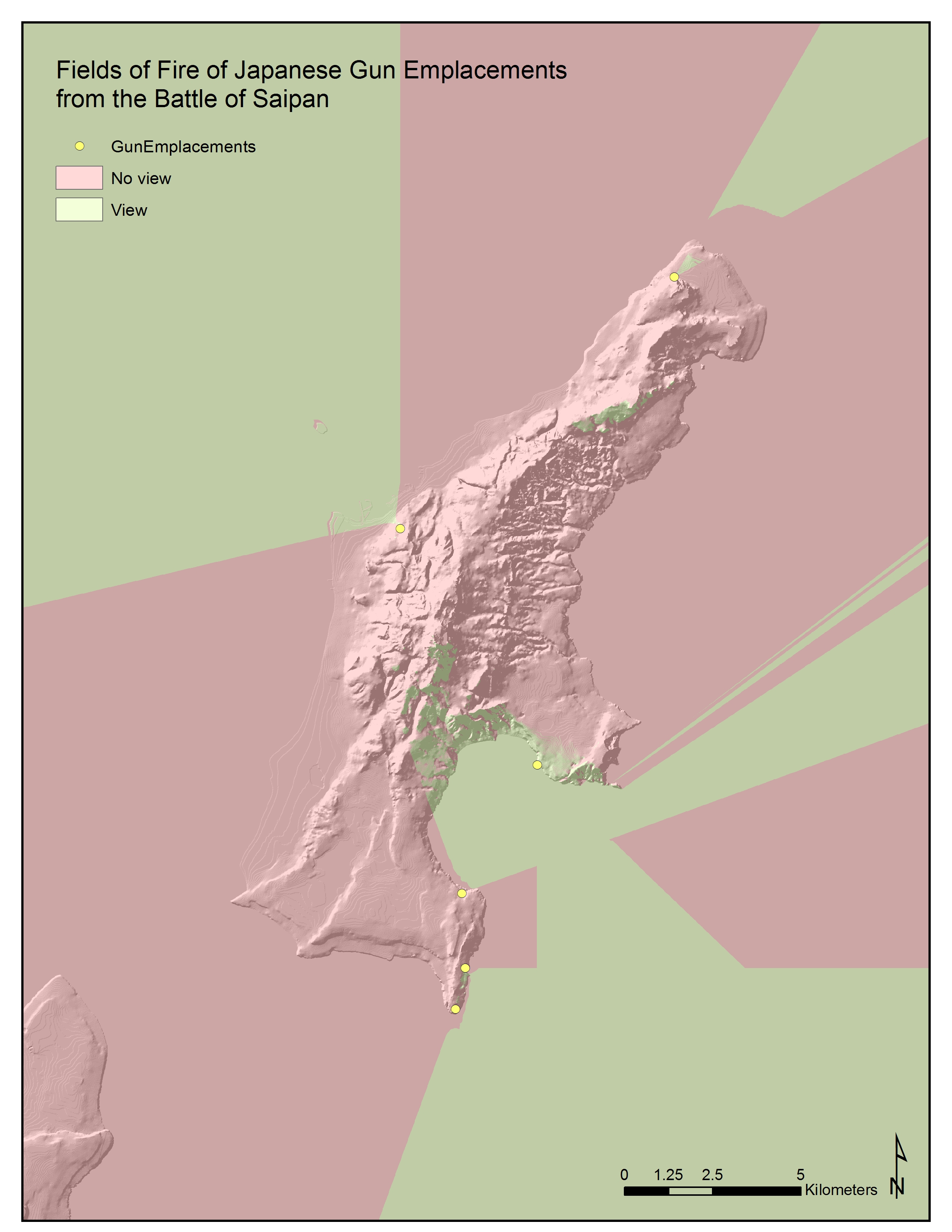

Results
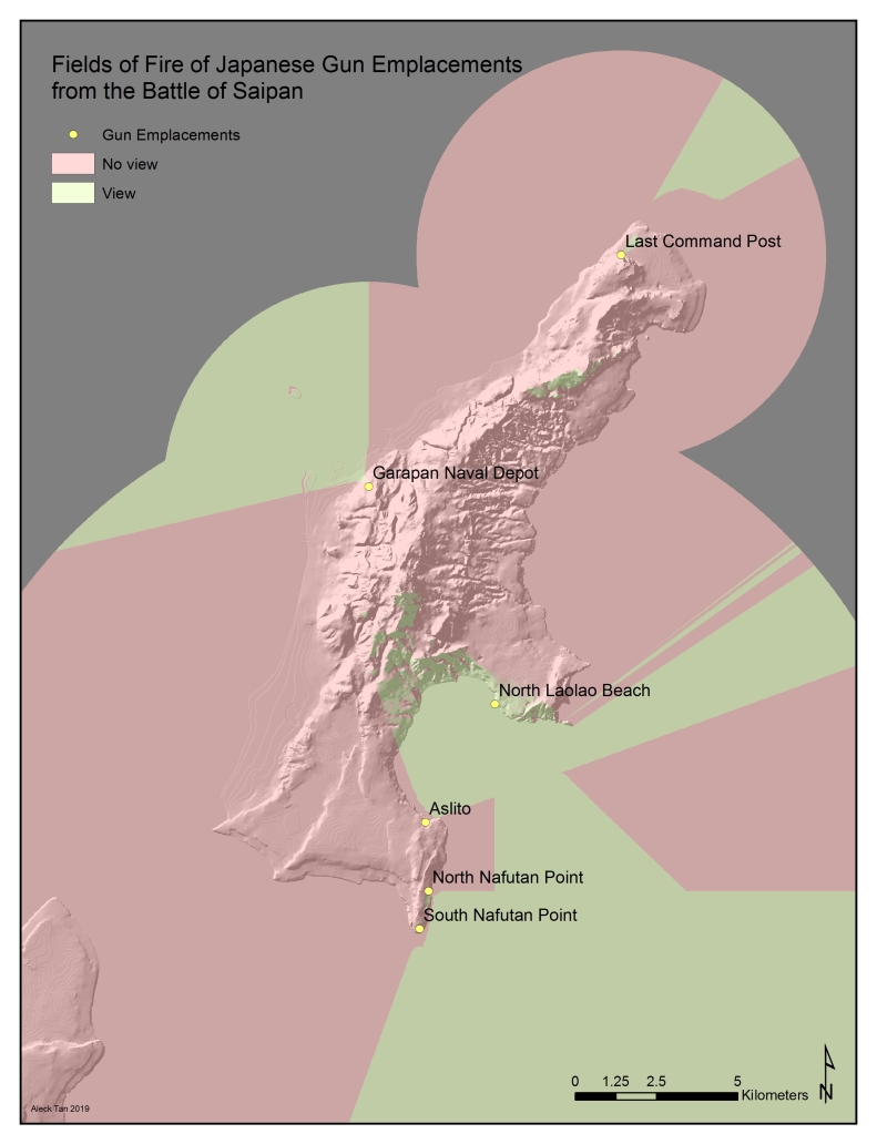
The resulting output is the visibility, or fields of fire, of gun emplacements. The light red displays areas that guns may not view or access. The light green displays areas that guns may view or access. These areas are bounded by the guns’ maximum range. It is important to note that this map does not represent all the gun emplacements from the Battle of Saipan, and only represents some of the positively identified gun emplacements in Saipan. One other reminder about the output data is that the fields of view are hypothetical, but display the idea that guns’ observations may be restricted by physical barriers or by how much the guns can swivel in place.
Summary and Conclusions
In summary, the model is useful for many reasons. The model can be applied to any battlefield. Another ECU archaeologist Madeline Roth is already interested in using it to create fields of fire in Palau. The model also only requires two datasets: elevation and gun emplacement information. It is not required to conduct fieldwork to collect gun emplacement information unless there is very limited information online. Overall, the model is an efficient way to determine fields of fire as it conducts a visibility analysis of gun emplacements and bounds the visibility by gun ranges in one process. It also takes into account the fields of view or restricted movement of the guns. In addition, many archaeologists are not familiar with GIS, but this model, along with instructions on how to run it, will make it easy for them to create fields of fire for their project areas.
There are is one major limitation to the model. Smoke, fog, clouds and other weather conditions may limit gun visibility. The model does not consider weather conditions as a factor in calculating the gun emplacements’ fields of fire.
Bibliography
NPS American Battlefield Protection Program
2016 Battlefield Survey Manual. U.S. Department of the Interior, National Park Service, Cultural Resources, Washington, D.C.
Maio, Christopher, David Tennenbaum, Craig J.Brown, Victor T.Maston, and Allen M.Gontza
2013 Application of geographic information technologies to historical landscape reconstruction and military terrain analysis of an American Revolution Battlefield: Preservation potential of historic lands in urbanized settings, Boston, Massachusetts, USA. Journal of Cultural Heritage 14(4): 317-331.
Roth, Madeline
2018 KOCOA Military Terrain Analysis and the Battle of Peleliu. NOAA Ocean Exploration and Research, NOAA Office of Ocean Exploration and Research. <https://oceanexplorer.noaa.gov/explorations/18peleliu/background/terrain-analysis/terrain-analysis.html> Accessed 24 April 2019.
Spennemann, Dirk HR
2017 The Japanese 20cm dual purpose gun at the ‘Last Command Post’, Marpi, Saipan, CNMI: The Appearance of the Gun in 1994 and 2007. 10.13140/RG.2.2.28303.18083.
